KEYNOTE
Exploring the Roman city of Pollentia and its Hinterland using multiplatform remote sensing imagery
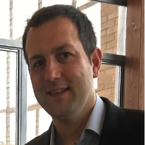
Dr Eduard Angelats
Centre Tecnològic de Telecomunicacions de Catalunya - CERCA, Spain
ABSTRACT
Pollentia, the Roman city in Alcúdia (Mallorca, Spain) has been the focus of extensive archaeological investigations for decades. Over time, the integration of Geomatics technologies has transformed archaeological research, allowing for increasingly precise documentation, analysis, and preservation of the site. Traditional surveys and documentation, including ceramic prospection and total station-based documentation and hand-drawing, have evolved into workflows that incorporate too geophysical surveys, aerial and UAV ortho mosaics generation and analysis, photogrammetry-based high-resolution digital surface model generation, automatic documentation, multispectral satellite series analysis, enabling the reconstruction of Pollentia’s architectural and landscape transformations.
In recent years, the use of multisensor and multiplatform remote sensing imagery has expanded archaeological research beyond the city limits to Pollentia's broader hinterland. These technologies allow the research team to identify areas with potential archaeological remains, detect previously unknown structures, refine interpretations of land use, and analyze historical agricultural practices. By monitoring spectral signatures and vegetation patterns over time, anomalies in vegetation indices can be identified, which helps to delineate potential zones of archaeological interest, and may indicate buried archaeological features too. Additionally, time-series analysis of vegetation dynamics supports the study of current and past land management practices.
This keynote will emphasize the methodological advancements in remote sensing for archaeological research, illustrating their impact through the case study of Pollentia and comparative examples from other Mediterranean sites. It will explore how these techniques are combined with geophysical prospection and other archaeological methods to enhance site documentation, analysis, and preservation. By examining successful implementations of these technologies in various contexts, the presentation will highlight the interdisciplinary nature of modern archaeological research and its contributions to sustainable management.
SPEAKER BIOGRAPHY
Eduard Angelats holds an M.Sc. in Telecommunications Engineering from the Technical University of Catalonia (UPC) and a Ph.D. from the same institution. His research career began in image processing at the Institute of Imaging and Computer Vision (RWTH Aachen University, Germany). In 2009, he joined the former Institute of Geomatics as a research assistant, where he contributed to the development of advanced trajectory determination systems based on robust and hybrid navigation approaches.
Since 2014, he has been a researcher at the Centre Tecnològic de Telecomunicacions de Catalunya (CTTC), where he is part of the Geomatics Research Unit. His work focuses on the development of advanced multi-sensor positioning strategies in GNSS-denied environments, integrating inertial sensors, vision-based techniques, and alternative navigation technologies to enhance accuracy and robustness. He has also worked extensively on sensor fusion methodologies, combining LiDAR and camera data acquired with RPAS (Remotely Piloted Aircraft Systems) and mobile mapping platforms, optimizing both navigation and high-precision 3D reconstruction.
More recently, he has explored the potential of multispectral and hyperspectral imagery from RPAS and Sentinel-2 for improved archaeological documentation, investigating novel remote sensing approaches for the detection of buried or non-superficial archaeological remains. His research also focuses on the use of remote sensing imagery and advanced processing and modeling techniques for water quality estimation and environmental monitoring in applications such as aquaculture, ecosystem management, and coastal zone monitoring.
Beyond his research activities, he has supervised undergraduate and master’s theses and is currently co-supervising several Ph.D. students. He is also actively involved in teaching, serving as a lecturer in the master’s degree in applications and technologies for Unmanned Aircraft Systems (UPC) and as an invited lecturer in the master’s degree in Advanced Studies in Archaeology (University of Barcelona). He is also part of the scientific team studying the Roman and Late Antique city of Pollentia (Mallorca, Spain).


